Subj: (11/17-Sat) El Corte de Madera
Creek Open Space Preserve + nature's fireworks
Date: 11/14/01 5:47:05 PM Pacific
Standard Time
From: PThuang
To: abao@cisco.com, svhikers@yahoogroups.com
CC: ai.luong@home.com, Tomo_Nguyen@yahoo.com
The banana slugs are back!
Remember them 6" long slimy but awefully
cute banana slugs we had seen in Purisima, Portolla, and Big Basin earlier
in the summer? Well, they're back! Because the ground is wet
again. Since some of us will watch the natural fireworks sunday morning
(at least I know I will), Sunday morning hike seems unreasonable.
Thus, let's have a hike on Saturday morning - the usual. The time
difference till the meteor show is too great to make a hike/potluck, so
let's just have the hike as usual in the morning, running into early afternoon,
then gather again in the wee hours of the morning for those brave enough
or have insomnia. I understand we have a few of them? hehe...
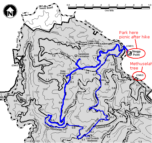
For the hike, let's try a
new one very close to Purisima - it's called "El Corte de Madera Creek
Open Space Preserve". Dont be fooled by the open-space in the name
of the park, though. It's anything but open. In fact, it's very much
like Purisima except that the trails are not one-way up and one-way down,
they're more up AND down at the same time. What's there to see?
Your friends, of course! Ok, there's more... there's a sandstone
formation somewhat like that of Castle Rock, lots of different trees, from
oak to manzanita to madrones to pines and other conifers. And, there's
one giant tree, called "Methuselah tree". It's 1800 yrs old and at
the base is a 14-ft diameter trunk. Remember the big tree in Nisene
Marks? Well, this is even more majestic. That tree had a 10-ft
diameter trunk perhaps. What else? There's a couple of nice
vista points overlooking the pacific (provided it's clear), and just generally
very nice trails. There are over 30 miles in trails, of which we'll
hike 6 to 8 miles. Elevation change will be up to 1,000 ft.
The schedule is like this:
7:45 AM. Meet at Bijan.
Those in the north can meet us at the parking area at about 9AM. (Skyline
Blvd, about 8 miles south of Rt 92).
8:00 AM. Carpool and leave
for the park. It should take no more than 45 minutes to get there.
(Via 280 north - Woodside - Kings Mountain)
9:00 AM. Start hiking.
1:00 PM. Finish hiking, have
picnic at Skeggs point (parking area - there're some tables and overlooks
San Mateo/Milbrae)
2:00 PM. Return to Bijan
3:00 PM to 12:00 AM (do whatever
else you need to do... eat, sleep, shop, read, till...)
12:00 AM (Sunday). Meet at
Bijan [again!] if there's enough interest for the meteor shower.
Drive to Windy Hill. (Arthur, Windy Hill is not that windy :)
It's just a name that is true sometimes. Most of the times I've been
up there, it's been calm, but of course we should all bring lots of warm
clothing just in case). There's no hiking involved!! We just
drive to this place and park! (If it's too cloudy, we'll find another
place or cancel)
1:00 AM - 3:00 AM. Watch meteor
shower, or fall asleep if that be what happens, hehe.
6:00 AM. Watch sunrise - Windy
Hill faces East so it's perfect. Ok, i was kidding. No sunrise watching,
unless of course you fell asleep during the meteor shower and can't get
up!
Notes:
- Bring warm layered clothing, that
is, once you start hiking, you might want to take the outer layer off.
Be prepared for this.
- No jeans if you can avoid it -
you will get warm with the hike, even sweat! Count on it. Wear sports
pants or shorts.
- Wear sturdy shoes - it's time
to leave the sneakers at home unless you want to muddy them big time.
- Bring a picnic lunch - we'll eat
after the hike and thus can leave the food in the car.
- Bring ponchos - in case of rain.
I dont think it'll rain on Saturday though. Bring umbrella if you
dont have ponchos.
- This is a moderate hike, similar
to Purisima but with more ups and downs.
I'll post details on the site later
on. If you want to go, please let me know. Indicate:
1) Whether you are going to hike?
If so, how many are coming? If you are coming, would you rather hike
Purisima?
2) Whether you want to see meteor
shower? If so, how many are coming?
Thanks you'all! Take care.
paul |